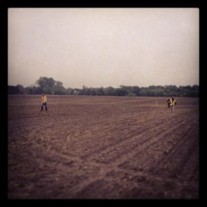
Stage 2 archaeological assessments consist of an intensive property survey after a thorough review of the background research undertaken for the property. The survey strategies we use are defined by the Ministry of Tourism, Culture and Sport’s Standards and Guidelines for Consultant Archaeologists. A pedestrian survey is undertaken on all arable lands where ploughing is feasible. Once lands are ploughed and allowed to weather, they are systematically walked at 5 m transects to permit recovery of cultural material on the surface of the soil.
Those lands that cannot be ploughed must be assessed by means of test pit survey typically at five-metre intervals. Test pits are approximately 30-40 centimetres in width and are shovel excavated to sterile subsoil which allows for an examination of stratigraphy and the detection of cultural soil horizons. The soil fill from each test pit, must be screened through a six-millimetre mesh and processed for cultural material. The pattern and intensity of testing may be adjusted in the course of fieldwork, due to environmental factors (e.g., topography) and/or the on-going results of test pits.
Any remains encountered during the course of a survey are then analyzed in ASI’s laboratories to determine their cultural and temporal affiliations and to assess their archaeological significance. For historic material, this analysis also involves comprehensive archival research.

Stage 2 assessments in urban centres requires a different strategy, as many areas have long and complex development histories. In urban contexts, it must be recognized that some features associated with historic archaeological sites may survive, as deeply buried deposits, in areas that have been developed and even re-developed (see Parliament Site – Featured Project). Only where land has been completely altered (i.e., removed or re-graded) to a depth of three metres or more should it be concluded that there is no potential for survival of archaeological remains. Our approach in urban areas is to develop a detailed land use history through review of historic maps, aerial photographs, assessment rolls, city directories, land registry documents and geotechnical studies.
This research allows us to identify zones of remaining archaeological potential or sensitivity, which are then examined through fieldwork involving borehole or test trench excavation. Sometimes this work is preceded by remote sensing (e.g., Ground Penetrating Radar, magnetometry, etc.) to allow for even more precision in the placement of in-ground test excavations. The early detection of a significant archaeological site through a detailed assessment allows for the modification of a project’s plans with a minimum of delay and expense. At this stage, various strategies, encompassing both the client’s needs and the heritage value of the site, are considered.
The Stage 2 assessment report will provide clients with our results and recommendations for next assessment steps (if necessary). We then submit the report to the MHSTCI for review and concurrence.